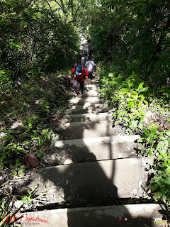
Name: Mt. Capistrano
Location: Sitio Binalbagan, Purok 9, Brgy. Simaya, Malaybalay City, Bukidnon
Height: 2,000 feet or 609.6 meters above sea level
Difficulty: 4/9
Trail Class: 1-3
Guide: Mandatory/Required
This stunning land form is crowned with magnificent steep, sharp rocks. People get curious of the photogenic rocky mountain which is a trending destination for most people around Bukidnon. Mt. Capistrano has become a popular tourist destination in Bukidnon for neophyte trekkers, nature trippers and seasoned climbers. It requires 1 to 2.5 hours trek. Another entry point is in Brgy. Managok, Malaybalay City.
MOUNTAIN FEATURES:
1. Registration Area
Every climber needs to pay an environmental fee of P20.00 at Ms. Imelda Villaruz’ residence.
*As of 2017, guide is made mandatory on trekking Mt. Capistrano. The rate is P500 for 5 pax.
2. Jump off point
In front of Villaruz’ residence is a waiting shed. That is the jump off to the summit.
3. Concrete Staircase
Though your walk is too short for a warm up, a concrete staircase marks the assault. Consist of 298 steps. One technique is not to hurry so you will not get tired easily.
4. Open Trail
The open trail is difficult and it has 80 degree slope, installed rope is a great savior to climbers. It is not a long trek, though.
5. Forested Trail
Another very difficult steep trail, this one is always wet, thus, so slippery. Though short, your balancing skill will be tested here. Prepare to crawl and get mudded. Twigs and roots spread their open arms to save your gasping and mud sliding soul.
6. Camp Site Area
The site is marked by bamboo plants. Some even camp and spend a cold night. Climbers take a rest.
7. Steep Rocky Trail
Though this part is not the most difficult, I see it the most dangerous. Hopping from a sharp rock to another requires balance, secure grip and careful movement to avoid scrape, abrasion, and worse, fall.
8. Rocky Summit
Wonderful rock formations adorn the summit. You can hop from rock to rock and take your best shot except jumpshot. Please don’t add up the vandals, broken glass and trash. There are designated sites for wastes.
9. Exhilarating Scenery
Being at the summit of a small mountain allows one to have an exhilarating 360 degree view of the lowlands with cool green rice paddies and mountain ranges.
10. Time Consumed
Trekking time takes 1 hour to 2.5 hours depending on physical fitness and pacing of the climbers. That includes rest, picture taking and selfie.
WHAT TO WEAR:
It’s a minor hike, so any type of outdoor clothes will do. For footwear, wear closed shoes or outdoor sandals. The trail can be a bit muddy or slippery, so rubber slippers are not really recommended.
WHAT TO BRING:
- Camera and smartphone
- Drinking water (you can buy water at the base/sari-sari store when you register)
- Shades
- A cap/headware
- Money
HOW TO GE THERE:
From Malaybalay City, take a south bound bus (multicabs are also available). Alight at Brgy. Aglayan. Hire a habal-habal to Sitio Binalbagan, Brgy. Simaya.From Davao City, take a CDO-bound bus. Alight at Brgy. Aglayan, Malaybalay. Hire a habal-habal to Sitio Binalbagan, Brgy. Simaya.
From Cagayan de Oro City, take a south bound bus. Alight at Brgy. Aglayan, Malaybalay. Hire a habal-habal to Sitio Binalbagan, Brgy. Simaya.
MAP:


No comments:
Post a Comment